Aperture Pulse® Wide Area Monitoring
On demand Wide Area Monitoring (WAM) and Change Detection for any Area of Interest (AoI)
What is Aperture® Pulse?
Aperture® Pulse is Atlas AI’s Wide Area Monitoring (WAM) solution for detecting and tracking physical and economic change across large geographies. It uses satellite imagery and proprietary AI to identify emerging construction, infrastructure, and settlement activity faster, more affordably, and at greater scale than traditional solutions. Read the product launch announcement here.
How is Aperture® Pulse different from other offerings?
Aperture® Pulse surpasses similar products for settlement mapping, land use - land cover (LULC), land parcels, or custom products based on satellite image tasking.
The industry has been accustomed to products like:
- Global Human Settlement Layer: Provides global built-up area mapping at coarse temporal and spatial resolution. While valuable for long-term urbanization studies focused on the late 2010s, GHSL is updated only periodically (e.g., every 5+ years), does not support user-defined AOIs or rapid response applications, and lacks integration into operational monitoring workflows.
- Microsoft Building Footprints: Provides precise building segmentation where available. These are static and infrequently updated, lack change tracking, precise temporal resolution, and geographic consistency.
- Typical Real Estate Parcel Records: Offer high granularity at the land parcel (not building structure) level, but are often out-of-date, lack consistent national or international coverage, and provide no visibility into unpermitted or informal development. They also fail to capture early indicators of construction or land use change.
- OpenStreetMap and Volunteer-Sourced Platforms: Coverage is uneven, update frequency is variable, and contributions are not guaranteed in strategic geographies. No quality assurance or service level agreements expected on these "as is" products.
- Custom Tasking via Commercial Satellite Providers: High resolution but expensive, slow to deliver, and not scalable for wide-area detection. Historical time series over the same areas unavailable because the satellites have only been in operation for a short time.
- Land Cover Classification Models: Focused on semantic labels rather than temporal change; not designed to detect new infrastructure or built-up areas at actionable intervals. Buildngs and general civil infrastructure are often lumped together.
Atlas AI's Aperture® Pulse sets a new standard relative to these existing offerings in several key ways:
- No Prior Location Knowledge Required
Unlike many change-detection systems that require a defined Area of Interest (AoI) or visual reference, Pulse can detect change without knowing where to look or what to screen for in advance.
- Scalability
Pulse supports continental-scale operations, processing millions of square kilometers in a single workflow.
- Global Consistency
Pulse's geography-agnostic models provide high detection success rates regardless of location.
- Temporal Flexibility
Users can monitor change in near real-time or analyze changes between any two points across the past decade.
- Affordability
Pulse operates at a fraction of the cost of custom imagery tasking or manual change analysis workflows.
- Efficiency
Aperture's automated approach to change detection consistently delivers results within 24 - 48 hours, even for wide areas.
How do I buy Aperture® Pulse?
Pulse is available through the self-service order workflow in the Aperture® Intelligence web platform. Sign up for your account today, if you're not already registered.
Here’s how it works:
- Log in to the platform and select the new Order WAM workflow.
- Enter your order details and use case description.
- To define your AoI, upload a geoJSON or draw it directly on the map.
- Select your monitoring time horizon and optional historical baseline analysis.
- Review instant pricing, adjust specs, and submit your order.
- Your Pulse WAM order will be delivered to your account dashboard or cloud bucket within 48 hours.
Watch this video for a quick end-to-end overview of the ordering process.
No sales calls, no lengthy scope reviews — just transparency, speed, and self-service control
What do I get when I order Aperture® Pulse?
Each Pulse order includes five data products, with embedded metadata. These are delivered in standard raster and vector formats for integration into your GIS, dashboard, or analytics workflows.
| Product | Description |
|---|---|
| Built-up Index (BU_I) | Pre- and post- raster layers (10m resolution) showing built-up presence. |
| Built-up Change Detection (BU_CD) | RGB raster showing new, unchanged, and removed structures. |
| Change Confidence Scores (BU_CC) | Raster scores indicating per-pixel detection confidence. |
| Built-up Change - Positive (BU_CP) | Vector polygons of newly detected built structures. |
| Built-up Change - Negative (BU_CN) | Vector polygons of removed structures. |
Can I get a sample of the Pulse product?
Yes! Atlas AI provides open-access samples under a CC-BY-NC 4.0 license. You can explore:
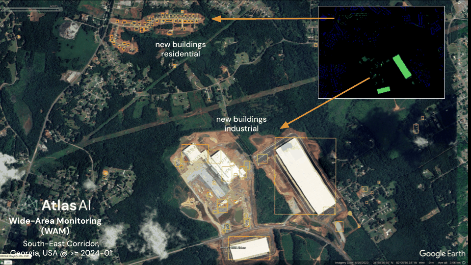
- US Interstate-85 Southeast Corridor: Residential, Commercial, & Industrial expansion between Atlanta to Charlotte
- Kaunas, Lithuania: Urban expansion in one of the fastest growing regions in the Baltics
Samples include raster and vector formats for review and integration testing. Just cite Atlas AI in any derivative works or presentations.
Please visit LINK for access to data samples.
How can I customize or add-on?
-
Integration with External Databases: Pulse outputs can be enriched with third-party databases such as real estate records, permitting data, and infrastructure registries. These integrations help contextualize detected change and support use cases in property analytics, infrastructure planning, and policy targeting.
-
Tip & Cue Monitoring with Very High Resolution (VHR) Imagery: For customers seeking additional validation or site-level insights, Atlas AI offers add-on support for Tip and Cue monitoring workflows using commercial very high-resolution (VHR) aerial and satellite imagery. This enables targeted analysis of high-priority locations identified by Pulse.
-
Custom Classification & Model Refinement: In addition to detecting built-up change, Atlas AI supports custom classification and targeted detection of specific change types (e.g., industrial vs. residential, informal settlements, or infrastructure upgrades).
Contact our team to explore how Pulse can be tailored to your data environment, or talk to us about add on workflows like Tip & Cue monitoring for site level analytics.
What else should I know?
- Refresh Rate: Pulse supports one-time orders or ongoing monitoring (e.g., biweekly, monthly).
- Integrations: Pulse outputs are currently delivered in standard raster and vector formats that users can ingest directly into their enterprise GIS systems, dashboards, or data lakes. API-based access and programmatic integration capabilities are coming soon.
- Support: Every account has access to onboarding and data interpretation guidance.
- Security: All Pulse data products are encrypted in transit and at rest.
- Licensing: Usage is governed by enterprise-friendly terms, and non-commercial research licenses are available.
Have more questions or want a guided demo? Reach out to our team at atlasai.co/pulse to get started.